
If you don't know where you are going, any road will take you there. : George Harrison (Any Road)
And a road with a divider will get you there faster. : Kaushal Kaushik
Although inspired by the line above (the line above) that we first heard from our Geography teacher back at school (in totally different context), yet our roadtrip was somewhat planned (on one long whatapp post) - force fitting 1200 kms in the space of 4 days.
Bangalore - Shravanbelagola - Belur - Halebidu - Chikmanglur - Sringeri - Agumbe - Maravanthe - Murudeswar - Jog Falls - Shimoga - Bangalore.
Nusrat further force-fitted Gokarna into the itinerary - but like the rest of it - it all turned out to be better than anticipated. Well it wasn't like we went to Europe or Mars. Actually, we didnt even leave the state of Karnataka (roaming expenses saved) - yet it was no less fun - for it wasn't just a journey down the highway lane, but the memory lane as well. The trip got over but we weren't done digging the Oak Grove stories.
Only Dubs (who had to abstain due to his forever withstanding permission issues) could have spiced up equations. But present or not, he played more important role in making this materialise then he can ever know. Thank you Dubs!
Also, thanks to Haddaway for literally keeping the tempo up and the energy flowing until thoughts of the working days came haunting back and dampened the amplitude of those headbangs.
tldr;
(The better part of the) four days summed up in four minutes.
If it were upto me, I would have bunked the first three stops (Shravanbelagola, Belur and Halebidu) and landed directly in Chickmanglur. But then the other two's enthusiasm surpassed my estimation of the same.
Shravanbelagola
You think the name is difficult. Try typing it as many times as I already have in this post.
Through my second visit to this Monolithic giant statue of Gomateswara, I did come across a couple of interesting nooks and corners that had escaped me the last time.
The approach upto the hillock having the statue is a pretty scenic drive. Then comes the climb. Must be over 500 steps. You might claim it to be more by what you feel (your legs feel) once your jack and jill are back down the hill.

Belur
(Not to be confused with Vellore)
You know what South Indian temples look like. Intricate carvings in every nook where light in its particle form can fall upon. How the hands reached those nooks is perhaps whole other level of science (and art). We discussed that it must be like each guy just picked up a pillar and spent his life masterfully chiseling away every square inch of it.

Halebidu
(To be confused with Belur - Its almost like a Deja Vu)
As if Belur wasn't enough - its like these two temples (Belur and Halebidu) in the vicinity of each other were in mortal competition - whose rocks are more designer?!
We got there late so had to dash for one circle through the lush green outreaches of the structure. It was difficult for our gaze to not linger on - but then there were those shouts in Kannada 'Banni <something angry> <something even angrier>'. We hurried through ignoring it hoping may be they were hurled towards others. Unfortunately, we were the only ones there.

Chickmanglur
What do mean spelling error? Its actually 'maglur' and not 'manglur'; but I have gone ahead with the general pronunciation.
Initially we were looking for hills which returned a 404 error. We stayed the night and in course discovered that more distance had to be covered to gain elevation. And boy did it get elevated! The winds on Mulayanagiri made us question ours (and others) choice of shorts.
Misty, rainy, windy - the change is almost so sharp that you can draw a boundary. Sprawling coffee estates all around made us want for a hot cup or two. Nusrat on his inability to locate a Coffee Day in sight - lamented in his rhyming plight - "Coffee coffee everywhere - not a drop to drink!"

Sringeri
And the sharks of river Tunga!
Actually they were just fish. But huge. So huge that they had run out of scales to cover their bodies - perks of being in the riverside of a temple. Harmless as they might have been - but just their sheer numbers and the way they splashed around for every bit of food thrown in - made me wary of putting my feet in water.
The Tunga flows lazily across with the Jyotirmatha established by Adi Shankarachaya on one bank and a 650 years old temple on the other. If Halebidu and Belur were art marvels - this one brought hardcore science into the already z-level competition. The 12 pillars outside the sanctum sanctorum (intricately carved majestic lions with spheres inside there mouth!) represent the 12 zodiac signs. The first rays of light fall upon the zodaic the sun is currently in. In the middle lies a big circular plaque with random straight lines intersecting each other - elaborating some shadow geometry you dont want me to explain. And the secret is being guarded (no photography allowed).
And we saw elephants.

Agumbe
Cherrapunji of south : Wikipedia
Enroute Maravanthe (from Sringeri), the degree of slope as well as the curve increased. It was ever more scenic and ever more green. And then it started to pour (skipping the drizzling and raining part altogther). The sobriquet provided by wikipedia stands justified.
(Note: Cherrapunji is a place in Meghalaya which records the highest rainfall in India. Sometimes its a neighbouring place called Mawsynram, but then Cherrapunji is more famous.)

Maravanthe
Sea on one side, river on the other.
Sometime around last year I had come across an article describing this place. Its about a kilometer long stretch of road - with Arabian sea on one side and river Kolluru on the other. Intriguing as it might appear - the truth isnt too far from the imagery. Other than perhaps the 4 lane-ing of the existing road which might just make the distance between the sea and the river a bit wider.


Murudeswar
Another temple. "When did we get so religious?"
Ever since we have had things to fear.
A high gopuram and an imposing Shiva statue and seashore around. I only wanted to be here because of the pictures I had seen. But was glad to hear yet another story where Ravana got duped by Gods who feared his increasing strength. The story stated in the beginning that Ravana was going to Gokarna. And we wondered why? Wasnt Sri Lanka a good enough weekend destination. As this discussion went on - it somehow remoulded our trip plans. Gokarna was inserted as a night stop before we set forth for Jog.

Gokarna
read Gau-karna in off-season
'Cause cows and buffaloes adorned the beautiful Kudle that we had seen strewn with eye candies on our earlier visits. They even tear down the shacks. "I had stayed there last time", I said pointing at a heap of burnt bamboo and infinite jungle behind it.
Luckily a couple stay and food options were still available and barely enough sunlight for us to complete one hearty splash in the water and sand.
Beach and beer go well together. I dont remember the rest of the night.

Jog Falls
India's highest. (Until they found a higher one in Meghalaya recently.)
The final day, the way back home was taken. Different from the one we had taken during the inward journey, this one cornered the Jog Falls a 100 kms in.
You have to view it from afar. The multilple falls - white-lining the mountain afront.

***
The last 400 kms were covered. Toll gates, signals welcomed us back. And the khooni Monday lay in the offing.
If you dont know where you are going, then any road will take you there. And then you are there. And then you get back to being the busy, and the tired, and the pursuing and the pursued.
(Until next time.)

And a road with a divider will get you there faster. : Kaushal Kaushik
Although inspired by the line above (the line above) that we first heard from our Geography teacher back at school (in totally different context), yet our roadtrip was somewhat planned (on one long whatapp post) - force fitting 1200 kms in the space of 4 days.
Bangalore - Shravanbelagola - Belur - Halebidu - Chikmanglur - Sringeri - Agumbe - Maravanthe - Murudeswar - Jog Falls - Shimoga - Bangalore.
Nusrat further force-fitted Gokarna into the itinerary - but like the rest of it - it all turned out to be better than anticipated. Well it wasn't like we went to Europe or Mars. Actually, we didnt even leave the state of Karnataka (roaming expenses saved) - yet it was no less fun - for it wasn't just a journey down the highway lane, but the memory lane as well. The trip got over but we weren't done digging the Oak Grove stories.
Only Dubs (who had to abstain due to his forever withstanding permission issues) could have spiced up equations. But present or not, he played more important role in making this materialise then he can ever know. Thank you Dubs!
Also, thanks to Haddaway for literally keeping the tempo up and the energy flowing until thoughts of the working days came haunting back and dampened the amplitude of those headbangs.
tldr;
(The better part of the) four days summed up in four minutes.
If it were upto me, I would have bunked the first three stops (Shravanbelagola, Belur and Halebidu) and landed directly in Chickmanglur. But then the other two's enthusiasm surpassed my estimation of the same.
Shravanbelagola
You think the name is difficult. Try typing it as many times as I already have in this post.
Through my second visit to this Monolithic giant statue of Gomateswara, I did come across a couple of interesting nooks and corners that had escaped me the last time.
The approach upto the hillock having the statue is a pretty scenic drive. Then comes the climb. Must be over 500 steps. You might claim it to be more by what you feel (your legs feel) once your jack and jill are back down the hill.

Belur
(Not to be confused with Vellore)
You know what South Indian temples look like. Intricate carvings in every nook where light in its particle form can fall upon. How the hands reached those nooks is perhaps whole other level of science (and art). We discussed that it must be like each guy just picked up a pillar and spent his life masterfully chiseling away every square inch of it.

Halebidu
(To be confused with Belur - Its almost like a Deja Vu)
As if Belur wasn't enough - its like these two temples (Belur and Halebidu) in the vicinity of each other were in mortal competition - whose rocks are more designer?!
We got there late so had to dash for one circle through the lush green outreaches of the structure. It was difficult for our gaze to not linger on - but then there were those shouts in Kannada 'Banni <something angry> <something even angrier>'. We hurried through ignoring it hoping may be they were hurled towards others. Unfortunately, we were the only ones there.

Chickmanglur
What do mean spelling error? Its actually 'maglur' and not 'manglur'; but I have gone ahead with the general pronunciation.
Initially we were looking for hills which returned a 404 error. We stayed the night and in course discovered that more distance had to be covered to gain elevation. And boy did it get elevated! The winds on Mulayanagiri made us question ours (and others) choice of shorts.
Misty, rainy, windy - the change is almost so sharp that you can draw a boundary. Sprawling coffee estates all around made us want for a hot cup or two. Nusrat on his inability to locate a Coffee Day in sight - lamented in his rhyming plight - "Coffee coffee everywhere - not a drop to drink!"

Sringeri
And the sharks of river Tunga!
Actually they were just fish. But huge. So huge that they had run out of scales to cover their bodies - perks of being in the riverside of a temple. Harmless as they might have been - but just their sheer numbers and the way they splashed around for every bit of food thrown in - made me wary of putting my feet in water.
The Tunga flows lazily across with the Jyotirmatha established by Adi Shankarachaya on one bank and a 650 years old temple on the other. If Halebidu and Belur were art marvels - this one brought hardcore science into the already z-level competition. The 12 pillars outside the sanctum sanctorum (intricately carved majestic lions with spheres inside there mouth!) represent the 12 zodiac signs. The first rays of light fall upon the zodaic the sun is currently in. In the middle lies a big circular plaque with random straight lines intersecting each other - elaborating some shadow geometry you dont want me to explain. And the secret is being guarded (no photography allowed).
And we saw elephants.

Agumbe
Cherrapunji of south : Wikipedia
Enroute Maravanthe (from Sringeri), the degree of slope as well as the curve increased. It was ever more scenic and ever more green. And then it started to pour (skipping the drizzling and raining part altogther). The sobriquet provided by wikipedia stands justified.
(Note: Cherrapunji is a place in Meghalaya which records the highest rainfall in India. Sometimes its a neighbouring place called Mawsynram, but then Cherrapunji is more famous.)

Maravanthe
Sea on one side, river on the other.
Sometime around last year I had come across an article describing this place. Its about a kilometer long stretch of road - with Arabian sea on one side and river Kolluru on the other. Intriguing as it might appear - the truth isnt too far from the imagery. Other than perhaps the 4 lane-ing of the existing road which might just make the distance between the sea and the river a bit wider.


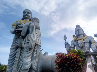
Murudeswar
Another temple. "When did we get so religious?"
Ever since we have had things to fear.
A high gopuram and an imposing Shiva statue and seashore around. I only wanted to be here because of the pictures I had seen. But was glad to hear yet another story where Ravana got duped by Gods who feared his increasing strength. The story stated in the beginning that Ravana was going to Gokarna. And we wondered why? Wasnt Sri Lanka a good enough weekend destination. As this discussion went on - it somehow remoulded our trip plans. Gokarna was inserted as a night stop before we set forth for Jog.


Gokarna
read Gau-karna in off-season
'Cause cows and buffaloes adorned the beautiful Kudle that we had seen strewn with eye candies on our earlier visits. They even tear down the shacks. "I had stayed there last time", I said pointing at a heap of burnt bamboo and infinite jungle behind it.
Luckily a couple stay and food options were still available and barely enough sunlight for us to complete one hearty splash in the water and sand.
Beach and beer go well together. I dont remember the rest of the night.

Jog Falls
India's highest. (Until they found a higher one in Meghalaya recently.)
The final day, the way back home was taken. Different from the one we had taken during the inward journey, this one cornered the Jog Falls a 100 kms in.
You have to view it from afar. The multilple falls - white-lining the mountain afront.

***
The last 400 kms were covered. Toll gates, signals welcomed us back. And the khooni Monday lay in the offing.
If you dont know where you are going, then any road will take you there. And then you are there. And then you get back to being the busy, and the tired, and the pursuing and the pursued.
(Until next time.)

****************************************************************************
Do not read between the lines.
Rights to exaggeration and bragging reserved.
Its not how it happened; its how you remember it.
No characterisation intended
Data and information may have been skewed to suit the storyline
Everything is relative to your perspective


